We've partnered with several local companies, instructors and guides to keep you up-to-date with the piste, off-piste and park conditions in Tignes and the surrounding areas.
More unsettled weather before settling down a bit from Tuesday in the Northern French Alps !
It’s been an epic week of off-piste skiing, with arguably the best snow conditions of the whole season! Following some resort level rain on Thursday, we just had another night of fresh snowfall so we wake on Friday with avalanche danger rating 4 again.
There are a variety of off-piste conditions at the moment. We currently have some great powder snow conditions, light and fluffy in places (especially the colder high north’ish facing slopes), in others densified by the wind, but very skiable.
With more fresh snowfall due next week, at least above 1800 m or so, we’re hoping for more great off-piste skiing conditions, at least some days, next week.
After any substantial fresh snowfall we’ll, as always, be choosing low slope angles, <30° (the steepest part of a red run) to start with, and keeping a wary eye out for any signs of recent avalanche activity.
Sadly (but predictably) sunny days after fresh snowfall this week have seen a ‘powder frenzy’ with the off-piste being rapidly tracked out with little/no regard for safety.
There have been many skier-triggered avalanches/slides this week, most of them thankfully without serious consequences. There was, however, a serious avalanche accident in the Chardonnet couloir, Tignes on Tuesday. This was a sunny day following 20 cm or so of fresh snowfall. Two off-piste skiers were caught by an avalanche that they triggered on a second lap of the same route they’d taken 20 minutes previously. One of them was flown to hospital in an unconscious state after being buried for 10 minutes. Link to report (in French).
The week ahead promises to be very similar, and will be another tricky one as far as avalanche danger goes. Temperatures will be yo-yoing again, with significant snowfall expected (sometimes rain) accompanied by wind.
Unsettled weather and plenty of snowfall in the Northern French Alps next week !
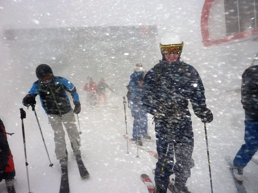
After a mild sunny start to the current week, it’s now back to winter with a vengeance! From Tuesday night, we had another period of extremely stormy weather, with howling NW winds and snowfall and much lower temperatures. 198 km/hr gusts were recorded at the Pissaillas glacier above Le Fornet (Val d’Isère) on Wednesday afternoon!
After Thursday’s snowfall, things we have a sunny Friday morning and avalanche danger rating 4 with fresh wind blown snow on all aspects. meaning it is easy for a skier to trigger an avalanche on all aspects and over the weekend before it gets very unsettled again from Monday to the rest of next week. A lot more snow is on its way!
Off-piste skiing conditions are very varied at the moment, largely due to the wind. Snow’s been blown all over the mountain, causing some deep drifting to occur, and some very bare areas where the snow’s been scoured off altogether. Despite poor visibility and strong winds, thanks to lower temperatures and fresh snow, we advise you to wrap up warm and get out there. There are some fantastic fresh light powder snow conditions to be found if you brave the elements!
With more fresh snow expected next week, we’re looking forward to some fantastic off-piste skiing conditions, although we’ll be choosing our low slope angles, <30° (the steepest part of a red run) to start with, and keeping a wary eye out for any signs of recent avalanche activity.
Unsettled weather and plenty of snowfall in the Northern French Alps next week !
After a mild sunny start to the current week, it’s now back to winter with a vengeance! From Tuesday night, we had another period of extremely stormy weather, with howling NW winds and snowfall and much lower temperatures. 198 km/hr gusts were recorded at the Pissaillas glacier above Le Fornet (Val d’Isère) on Wednesday afternoon!
After Thursday’s snowfall, things we have a sunny Friday morning and avalanche danger rating 4 with fresh wind blown snow on all aspects. meaning it is easy for a skier to trigger an avalanche on all aspects and over the weekend before it gets very unsettled again from Monday to the rest of next week. A lot more snow is on its way!
Off-piste skiing conditions are very varied at the moment, largely due to the wind. Snow’s been blown all over the mountain, causing some deep drifting to occur, and some very bare areas where the snow’s been scoured off altogether. Despite poor visibility and strong winds, thanks to lower temperatures and fresh snow, we advise you to wrap up warm and get out there. There are some fantastic fresh light powder snow conditions to be found if you brave the elements!
With more fresh snow expected next week, we’re looking forward to some fantastic off-piste skiing conditions, although we’ll be choosing our low slope angles, <30° (the steepest part of a red run) to start with, and keeping a wary eye out for any signs of recent avalanche activity.
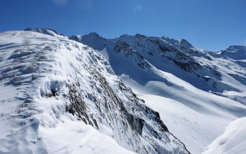
A bizarre three days of weather this week will be followed by a calmer weekend and fresh snowfall at the start of next week
In three days we had drenching rain up to 2700m, followed by a very mild grey and flat light day with slushy snow, followed by a very cold day of monster winds (217km/hr) that blew the authors shutter off its hinges. See the rain in this video
This left us with a weird snowpack. Look at this image taken on 6th Feb of the refrozen shiny crust, also showing rivers of water that had flowed under the snowpack during the warm weather (2500m in Tignes). There was cold dry snow that had fallen at the end of the storm, but it had been blown away by the wind.
But at the same time in shady sheltered spots, the powder that fell remained and offered real powder skiing on Wednesday 5th Feb.
Fortuntately the weather should settle down this weekend.
It looks like becoming a little more stormy again from Monday to Wednesday with further snowfall expected in the mountains of the Northern French Alps.
The quality of off-piste snow is very varied at the moment. Wind and rain have really affected the surface snow, making it very crusted and difficult to ski in places. In more sheltered spots in the lee and in gullies, there are some excellent strips of powdery off-piste skiing to be found.
Because the snow surface varies so much, we really need to keep our concentration as we ski, keeping our eyes open for what’s ahead. After recent storms, there’s also some serious rough avalanche debris out there that is difficult to traverse through.
Recent history of the snowpack
Recent high winds, maximum speeds of 217 km/hr on the Pissaillas glacier (above Val d’Isère/Bonneval), have been blowing the snow around (and sometimes off) the mountain.
These winds were accompanied by persistent precipitation, mainly in the form of rain, drenching the snowpack, particularly at 2700 m and below.
The wind and rain have caused a lot of the steeper slopes to purge themselves of snow, making for a more stable situation after the initial instability.
Snowpack stability below 2700 m-ish has now vastly improved on all sides of the mountain thanks to this deeply humidified snowpack, followed by consolidation and refreezing during sub-zero temperatures on Tuesday night into Wednesday. Things have now really firmed up, making for a much safer situation as far as avalanches go. The snowpack, at least below 2700/2500 m, is now a lot more stable than it was before the recent episode of persistent rain.
Even after the next expected snowfall on Monday/Tuesday, although the top layer of fresh snow may be unstable in the short-term, the deeper layers will remain solid due to all this week’s humidification and subsequent refreezing/consolidation.
Higher altitudes above 2700 m, which recently received snowfall instead of rain, are not currently so stable because they haven’t been as saturated and consolidated as the lower ones.
What is the current avalanche risk in the Northern French Alps/Savoie?
As we write (Thursday 6th Feb) the avalanche risk is a 3/5. We expect it to decrease to 2/5 over the next few days, rising again with any significant amount of fresh snowfall at the beginning of next week.
For any specific points about snow stability, you need to check the daily avalanche bulletins, particularly when the fresh snow comes next week.
What does this mean for off-piste skiers and snowboarders?
The snowpack, at least below 2500/2700 m, has currently become a lot more stable after recent episodes of prolonged rain.
Be more wary of the colder higher altitudes where the snowpack has not consolidated as well, and where it has been more windblown.
Consult the daily avalanche bulletins for any specific points about snow stability, particularly when the fresh snow comes next week.
Where is most at risk at the moment?
Steep slopes with fresh snow on them and terrain traps beneath them are always going to be particularly at risk.
Particularly beware of slopes above 2500/2700 m, which didn’t benefit from the solidifying effect of the rain’s humidification and subsequent refreezing.
How does the forecast look for the coming week?
FRIDAY 7 FEBRUARY Sun and warmer, Nice sunny and mild day. Maximum temperatures: 12 DG in Chambéry, 8 in Modane, +4 to 2000 m, +1 to 3000 m.
Isothermal 0 DG: 2700 m. Isothermal -10 DG: 4300 m. Wind at 2000 m: calm, locally S 15/30 km / h on the Bauges. Wind at 3000 m: S 10/30 km / h.
SATURDAY FEBRUARY 8 Quite handsome! Fairly sunny in the plain as in the mountains. A few cloud banks of altitude around 4000/6000 m. Calm, bright, comfortable atmosphere. Maximum temperatures: 8/11 DG in plains, +2 to 2000 m, -3 to 3000 m.
Isotherm 0 DG: 2400 m. Isothermal -10 DG: 4000 m. Wind at 2000 m: calm, locally SW 20 km / h on the Bauges. Wind at 3000 m: SW 10/30 km / h.
SUNDAY FEBRUARY 9 Sun then clouds. Sun in the morning, becoming cloudy then cloudy in the afternoon. Maximum temperatures: 10/12 DG in plains, +3 to 2000 m, -5 to 3000 m. Isotherm 0 DG: 1800 then 2300 m. Wind at 2000 m: SW 20 then 30/50 km / h. Wind at 3000 m: SW 30 then 50/70 km / h.
Night from Sunday to Monday: small rainy passage, light snow above 2000/2200 m. Stormy W wind in the mountains.
MONDAY 10: Monday 10: passage of a disturbance, grey and rainy weather, rain / snow limit around 2000 then 1500 m. Strong W wind at high altitude.
TUESDAY 11: Tuesday 11: overcast, rainy periods. Snow in the mountains above 1200/1500 m. Strong W wind in the mountains.
WEDNESDAY12: continuation of the disturbed current from the west, rain-snow limit decreasing towards 1000 m.
THURSDAY 13: still cool and unstable, with frequent showers and snow in the mountains from 800/1000 m.
FRIDAY 14 and SATURDAY FEBRUARY 15 Weather becoming quieter again, with a risk of fog or low clouds in plains and valleys. Rising temperatures, especially at altitude.
Tip of the week
Be careful of finding yourself on hard crust that is icy with no grip. There is a lot about. Look for the pockets of soft snow on leeward slopes (SE E and NE) There is also a lot of avalanche debris from spontaneous avalanches that came down during the changing temperatures and storms. Plan your routes, know where you are going.
Snowfall on and off in the Northern French Alps next week!
We needed more snow and we got it! Winter returned with a vengeance last Tuesday and Wednesday, bringing plenty of fresh snow accompanied by wild north-westerly winds.
Read our blog on the snowpack before the storm and the weak layer
Thursday was a glorious blue sky powder morning with very variable snow depths due to the wind. But there was plenty of powder to go around. The wind had come from the NW, so we found the most snow on SW, S, SE, E, and NE slopes.
Temperatures are due to rise a little, making the rain/snow limit around 2000 m or so. Higher altitudes will be reaping the rewards, while it could sometimes be raining below 2000 m. However, there’s a very good chance that skiing could be excellent at various points over the next week!
Violent north-westerly winds (gusts up 180 km/hr recorded at around 3500 m above Le Fornet) have blown the snow all over the place, making it difficult to say how much fresh snow has actually fallen. Needless to say, that following these high winds and large quantities of fresh snow, the avalanche risk has risen to a considerable 3/5, or even a high 4/5. Check out what the avalanche danger ratings mean.
recently has been in the trees, where visibility has been better and the snow has been less affected by the ravages of the wind.
Recent history of the snowpack
Off-piste snow depths have increased, although the surface is very windblown, especially at high altitude. In some exposed areas the snow has been blown off completely. In wind-exposed areas above 2500 m, the snow surface is very irregular and hardened.
tative avalanche blasting to secure the pistes on Wednesday morning revealed a high amount of snowpack instability, with several distance-triggered avalanches occurring.
There is also a weak layer in the snowpack that we spoke about in our previous blog. click here
What is the current avalanche risk in the Northern French Alps/Savoie?
At the time of writing (Thurs 30th Jan) the avalanche risk has gone down from a high 4/5 to a considerable 3/5. However, for us, the risk is a ‘very high 3 bordering on 4’ possibly for the next few days if it continues to snow. We believe there’s going to be a high danger of triggering avalanches, especially when visibility improves, along with the lure of skiing fresh powder.
Following other people’s tracks is a particularly easy trap to fall into. Don’t do it unless you know that where they are leading you is safe.
What does this mean for off-piste skiers and snowboarders?
There is going to be fantastic skiing for the next week, especially when the sun comes out.
Be wary of the weak layer if you are on slopes that were not heavily skied before. Henry’s Avalanche Talk heard some whumphing on Thursday which is a sign of a weak layer collapsing
Be cautious about sunny slopes warming up and the risk of spontaneous avalanches. This is particularly an issue below 2300m.
Where is most at risk at the moment?
Steep slopes with fresh snow on them and terrain traps beneath them are going to be particularly at risk. The best advice for the next week is to stick with slopes under 30 degrees. And if you do go steeper, make sure there are no terrain traps below you (cliffs, bowls, barriers, trees etc.)
How does the forecast look for the coming week?
Above-average temperatures with a mix of cloud, sun, snow and rain below 2000m, before the temperature drops to normal on Wednesday and this is followed by a dry sunny period
FRIDAY 31
Cloudy sky at daybreak with a little rain in places especially on the west of the department, rain-snow limit around 2300 m. Quickly in the early morning the peaks emerge from the layer. During the morning the clearings this generalize to all the massifs except on the Bauges, the North of Beaufortin and the west of the Vanoise which remain still in the clouds. The sun prevails everywhere in the afternoon with only a few nasty residues hanging here and there. Isotherm 0 ° C: between 2400 and 2700 m. Maximum warm temperatures for the season: around 11 to 14 degrees below 1000m Wind at 3000 m North generally 20-30 km / h except 40 to 60 over Haute Maurienne. Weakening everywhere by midday Lower locally strong gusts on the edge of the Italian slope, diminish in the morning.
SATURDAY 1 Becoming rainy Cloudy sky at daybreak. Then the cloudy veil thickens rapidly from the west. By mid-day the sky is overcast everywhere, except on the peaks bordering Italy, with wells already on the west of the department. The rain reaches all the massifs during the afternoon, the snow-rain limit remains high descending u better around 2000 m. Quantities of water expected until Sunday morning: 10mm, loc 15mm of rain on the west 5 / 10mm in the center and less than 5mm on the east of the department. The equivalent in cm of snow above 2200m only. Isotherm 0 ° C: 2700 then 2300 // 2400 m during the day. Wind at 3000 m: WSW to WNW 20-30 then 40-60 km / h at the front crossing, locally 50-80 km / h on the Italian border. Strong gusts from the west in the afternoon along the Italian slope.
SUNDAY 2 Bad: Rain and strong wind Overcast in the early morning, then an active warm front passes over the department. Heavy rain in the afternoon with a snow-rain limit going up to about 2500m all accompanied by strong gusts of north-west wind reaching 100km / h in Haute Tarentaise and Haute-Maurienne where it will rain less. Significant quantities of water expected in the west (30 to 50mm to be confirmed) 10 to 15mm in Haute Tarentaise and Haute-Maurienne. Very windy snowfall at high altitude.
MONDAY 3: The fast current of WNW turns west and accelerates further. Few residual showers early in the morning, then the cloudiness widens. The sky charges again in the night. Isotherm 0 ° C slightly increasing, pus decreasing at night around 1900 m (at least).
TUESDAY 4: The very fast current from West to NW turns to NW then North, generating strong winds at least in very high mountains. Many clouds and marked precipitation; gusts of wind sometimes descend to the plains and low valleys. Isothermal 0 ° C down around 500 m (at least). Snow can descend to the plain.
WEDNESDAY 5: The north current remains fast. Thunderstorms, little by little snow showers, and more gusts of Bise. Isotherm 0 ° C around 600 m; the snow barely rises.
THURSDAY 6: The fast north current turns to the NNE and becomes more moderate. A partial cloud sea persists, locally over 3000 m in the morning, up to over 1500 m in the evening, or even lower at night, with rare drops or flakes still possible in the morning. Isotherm 0 ° C rising around 900 m on the Prealps side, 1700 m in interior mass.
FRIDAY 7 and SATURDAY 8 The current from NNE then North becomes weak then takes a West trend. More or less sunny, cloudy periods. Isotherm 0 ° C rising around 2200 m (at least).
Tip of the week
In the words of Alain Duclos, Avalanche Expert, sticking to low-angled slopes with wide skis is not a bad option this week.
There is a hidden demon under the snowpack in form of a weak layer read our post
First tracks in Grand Vallon 30th Jan 2020, Photo: Chris Howe, Skiers Vincent Giraud and John Eales
Hoping for snowfall in the Northern French Alps at the start of next week!
Unfortunately temperatures are becoming mild for the time of season again, but altitudes above 1600 m should benefit from this fresh snow.
Around 10-15 cm fresh snow fell last Friday night, with air temperatures dropping considerably. This made for some great light-powder skiing over the weekend, particularly in gullies and bowls, where the wind had blown the snow in, making for nice deep powder in places.
Strong winds since then have been affecting the snow quality, particularly in high exposed areas. We’re finding a wide variety of off-piste conditions out there at the moment: occasionally dense powder on high cold slopes sheltered from the wind; hard wind-blown snow in more exposed areas (or blown off altogether); and crusted snow on the sunnier slopes first thing, which has humidified during the warm days and then refrozen in the cold nights.
You’ve guessed it…… we need more snow again!!!
Within a day or two of any fresh snow, we’re back to using our touring skis and skins to find the best snow. Ski crampons or ‘couteaux’ have also become extremely useful to give us more grip on the icier snow when skinning up on icy traverses.
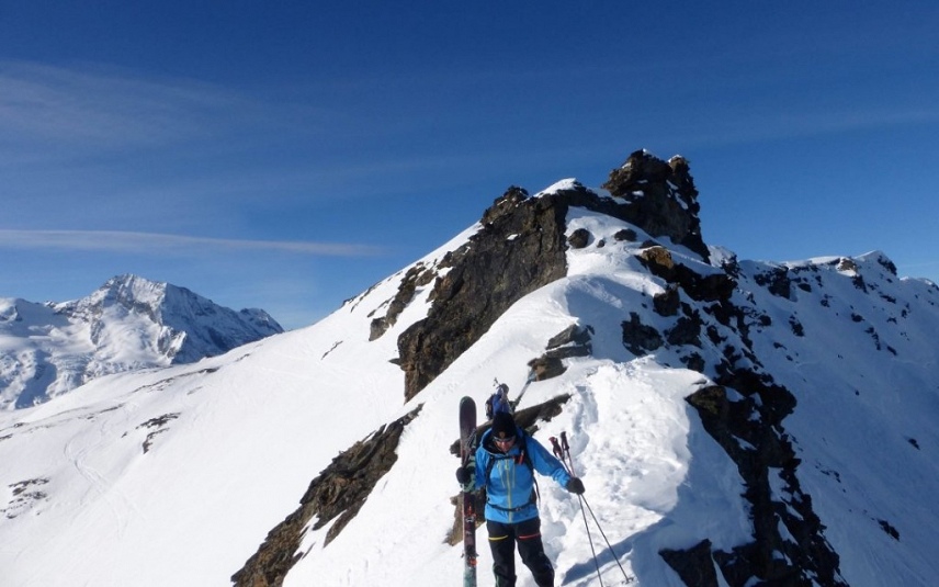
There are fresh powder turns to be found, but you need to work for them Credit to Vincent Giraud and SCGB clients John Eales and Chris Howe for photos
This may not appeal to powder-hounds, but we’ve been enjoying our touring, getting fit and spotting wildlife along the way. The off-piste skiing’s not always been easy, but we’ve always found something to see and do.
Recent history of the snowpack
Snow depths are getting rather scratchy below 1500 m, and the snow surface is very windblown up high. We’re keeping our fingers crossed that next week’s predicted snowfall will materialise!
Snow on piste is still in excellent shape thanks to the hard work of the piste maintenance services.
What is the current avalanche risk in the Northern French Alps/Savoie?
The avalanche risk is currently around a moderate 2/5, sometimes going up to a considerable 3/5 above 2000 m. See definitions of the different avalanche ratings here. The reason for the difference is due to high wind causing snow to drift and accumulate on leeward slopes near mountain summits and passes. These areas of windslab could be triggered into an avalanche by skiers passing by on these high leeward slopes.
If anywhere receives a substantial amount of fresh snow (20 cm or more) that risk will increase in the short-term.
There are still numerous glide cracks around. Don’t be too fearful of them as you won’t trigger them, but don’t hang around underneath them either.
What does this mean for off-piste skiers and snowboarders?
Be prepared to walk and climb to find fresh untracked snow. But think very carefully about where you go. A lot of the snow is wind affected and difficult to ski. The fresh powder turns in our photo are in some north-facing sheltered spots
Where is most at risk at the moment?
The highest risk to skiers and snowboarders is, as always, on steep slopes exposed to terrain traps. This is particularly the case now, with a lot of hardened or crusted snow on steep slopes above cliffs and rocks.
Stay in control when traversing or skiing down, to avoid going for a long, potentially very dangerous slide. Use ski crampons when walking up on icy traverses.
Keep an eye on glide cracks and don’t hang around under them for long, or tour up underneath them.
How does the forecast look for the coming week?
There is an indication we may some snow next week. but the amount is very uncertain. High pressure still dominates the weather pattern over the Alps and the general weather pattern is to expect dry weather with average or above-average temperatures and quite a bit of random cloud.
There is no sign yet of major break in the weather that would bring really big snowfall
FRIDAY JANUARY 24 Hazy sky, a little snow in Haute-Maurienne, mixed with sand, looks weird. The sky is congested by numerous clouds of altitude, often quite dense and hanging on the highest peaks. Flat light day in the mountains. In Haute-Maurienne, the clouds even drop a little snow (mixed with a little sand) above 1200/1400 m in the afternoon and 1000/1200 m the following night. The quantities remain small, with a maximum of just over 5 cm on the border ridge. Foehn and Lombarde are blowing moderately, with some peaks at 40/50 km / h. Maximum temperatures: 8 to 10 ° C at low altitude, 1 to 3 ° C around 2000 m below the Foehn, and a notch colder in Haute-Maurienne (-2 ° C to 2000 m) Isotherm 0 ° C: 1600/1900 m in Haute-Maurienne, 2100/2300 m everywhere else. Wind at 2000 m: Southeast 20/40 km / h in Maurienne, weaker elsewhere. Wind at 3000 m: Southeast 30/40 km / h, temporarily 50 km / h in Maurienne.
SATURDAY JANUARY 25 Clouds with a few clearings Sky always with clouds at altitude clinging to the highest peaks, which can also double in places of low clouds. Some thinning is possible locally, however. Minimum temperatures: -1 / -3 ° C in plain and valleys. Maximum: 7/8 ° C at low altitude, -1 / + 1 ° C around 2000 m. Isotherm 0 ° C: around 1700/1800 m. Weak wind at altitude, going to the southwest 10/20 km / h.
SUNDAY JANUARY 26 Always cloudy, light precipitation in the Pre-Alps Clouds are still very present in the Savoyard sky, they can give some light precipitation over the the Pre-Alps (flakes above 1100/1300 m). Drier weather in the interior massifs, with even some clearer thinnings towards the Haute-Maurienne. Minimum temperatures: -1 / -3 ° C in plain and valleys. Maximum: 7/8 ° C at low altitude, -3 / -1 ° C around 2000 m. Isotherm 0 ° C: around 1600/1800 m. Wind at 3000 m: West 10/20 km / h. Weaker or light south wind at lower altitude.
MONDAY 27: Gradual degradation Cloudy Sky covering itself during the day as a new break in the weather arrives. A few snow flakes in the afternoon (above 1400 m) from Chautagne to Beaufortain. The following night, the precipitation intensifies and reaches the interior massifs. Isothermal 0 ° C around 1600/1900 m.
TUESDAY28: Snow in the mountains New weather system coming from west to altitude. Overcast with rain in the plains and snowfall above 1500 m at first, then subsiding. Quantities may be significant but very uncertain. Different weather models disagree on this
WEDNESDAY 29: Cool weather and return of the sun The clouds leave the department and the sun resumes. It is a little cooler and the 0 ° C isotherm is around 1200/1400 m
THURSDAY: Sunny, again milder After dissipation of some greyness in plain and low valleys, the sun reigns supreme in the sky of Savoie. The 0 ° C isotherm moves sharply upwards, to around 3100/3300 m.
FRIDAY JANUARY 31 and SATURDAY FEBRUARY 1 Alternating periods of bright spells and temporarily more cloudy periods. Little or no precipitation to expect. Temperatures well above seasonal norms
Tip of the week
If we get 15 cm or more new snow, test out the ‘low-hanging fruit’ to start with, keeping to low-angled slopes at first, rather than dashing out onto the steep slopes.
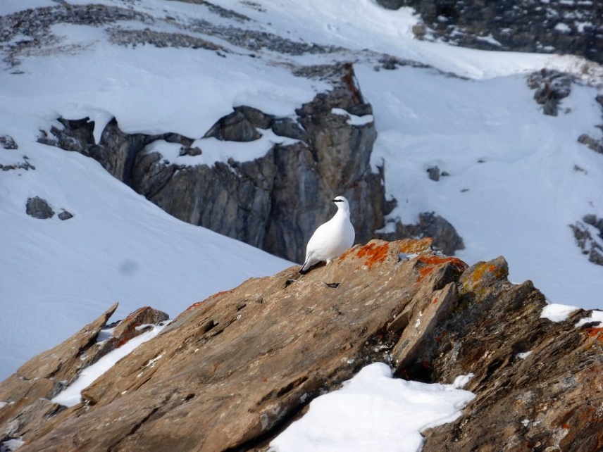
Perdrix Blanche (white partridge) as spotted by Wayne Watson
A little snow Friday afternoon into Saturday, followed by another dry week!
But there is frissette (gobelet, facets) sitting on top of the current snowpack in shady places
If we get 10cm or more new snow, then be very wary of steep, shady northeast, north and northwest slopes. The frissette (gobelet, facets) will be underneath and the slope could slide away from underneath, taking you into terrain traps. If there is more 20cm or fallen or windblown snow then it could avalanche and bury you.
This video shows an example of this Frisette found in resort in a shady spot at 1850m
Most of the Alps look like getting a little bit of fresh snow between Friday and Saturday. Some areas will get a lot more than others. For example, the west of Savoie (the foothills near Chambery) may receive over 30 cm fresh snow above 1700 m, whereas more eastern parts like the Haute Tarentaise (Val d’Isere) may only get up to 10 cm.
Even 5 cm of fresh snow can make a massive improvement to the off-piste quality and give us a new canvas to play with though. So bring it on!
Whilst there will be some risky areas due to the Frisette. Many slopes will be very safe, so there will be many opportunities to enjoy the new snow. Places that were heavily tracked out before the snowfall will not have the weak layer. Nor will slopes that were exposed to sunshine and where the Frisette did not develop.
We’ll continue using our touring skis and skins, doing a fair amount of walking to find the best snow. Ski crampons or ‘couteaux’ have also become extremely useful to give us more grip on the icier snow when skinning up on icy traverses.
Some of the best quality off-piste snow over the last few days has been in well-travelled off-piste areas exposed to a bit of wind. Here, wind-blown snow has settled on top of, often smoothing out, previous tracks. This ‘soufflée dure” snow is smooth, grippy and ‘chalky’ in texture, and great fun to ski.
Snow on steep sun-exposed, particularly south-facing, slopes is usually hard and crusted first thing in the morning. As the day goes on it softens up (then refreezing again overnight, so tricky to ski the next morning).
There’s still a real danger of going for a dangerous long slide on these steep icy slopes, which could be fatal if there are cliffs, rocks or other obstacles below you. Keep your skiing and speed under control.
What is the current avalanche risk in the Northern French Alps/Savoie?
The avalanche risk is currently between a low 1/5 to a moderate 2/5. See definitions of the different avalanche ratings here.
In terms of avalanche risk, there’s currently an extremely minimal risk to off-piste skiers and boarders, mainly from rare release of glide cracks. See our previous blog for more information on these.
Don’t be too fearful of them as you won’t trigger them, but don’t hang around underneath them either. If anywhere receives a substantial amount of fresh snow (20 cm or more) that risk will increase in the short-term.
What does this mean for off-piste skiers and snowboarders?
There is currently minimal avalanche danger. That isn’t to say ‘none’ – even a small avalanche on a steep slope above a cliff could have disastrous consequences.
The main risk to the off-piste skier at the moment is one of losing control, falling, and sustaining a sliding accident on steep, hard icy snow.
Where is most at risk at the moment?
This quote is from the professionals WhatsApp group around Tignes, Val d’Isere, St Foy, Les Arcs. This looks forward to the impact of fresh snow falling on the Frisette.
…. As you have noticed, the flat face “crystals” are very present in cold areas (North, West face and on the flat) What we call “frizz” is pleasant to ski is in fact gobelet . Our snow scientists tell us that the next snowfall expected Friday (15 to 30 cm) will rest on these surfaces without cohesion. The discussion focused on higher risks un unskied areas versus the hyper-tracked areas off the off-piste. The biggest risk will be in the zones that have not been skied. The risk will be lower in the zones that were “tracked out”
The highest risk to skiers and snowboarders is, as always, on steep slopes exposed to terrain traps. This is particularly the case now, with a lot of hardened or crusted snow on steep slopes above cliffs and rocks.
Stay in control when traversing or skiing down, to avoid going for a long, potentially very dangerous slide. Use ski crampons when walking up on icy traverses.
There’s been very little glide crack (brown frown) avalanche activity over the last few days. But still keep an eye on these cracks and don’t hang around under them for long, or tour up underneath them.
How does the forecast look for the coming week?
High pressure is still in charge, so the snowfall this weekend will be weak. There are signs that the blocking high over Europe in January will decline towards to end of the month and snow may appear after 25th Jan, but it will be patchy until the high pressure completely colapses
FRIDAY JANUARY 17 Snowfall afternoon and especially evening. Beautiful at daybreak becoming cloudy from the west in the morning. Snow on the Bauges in the early afternoon later on the eastern massifs. The precipitation is highest in the evening, it continues the following night becoming weak. Snow rain limit around 1300 / 1400m at the start of the episode, rapidly lowering around 1000 / 1200m during the afternoon, 700 to 800m in the evening and up to 400m in the Maurienne and Tarentaise valleys during the night for the last flakes.
Quantities expected on Saturday morning above 1500m: 20 to 30 cm on Bauges, Beaufortin and Lauzière. 15 to 20 cm in Vanoise and Maurienne, 10 to 15 in Haute Tarentaise and 5 to 10 cm in Haute Maurienne Maximum temperatures of 7 to 9 degrees in plain before the rain. Isotherm 0 ° C: around 1600 m during the day near Piedmont, down around 1400 m on the Prealps side then 1200 m in the evening; down everywhere around 1000 m at night. Isotherm -10 ° C down around 2100 m, and -20 ° C down around 3500 m. Wind at 3000 m: South in the morning it turns North West 20 to 40 km / h when passing the front
SATURDAY JANUARY 18 Improvement and fresher Clogged at dawn with still rare flakes, then the clouds dissipate partially first above 2000m with a sea of clouds below then beautiful on all the massifs at midday with locally just a few residue from clouds below 1500m. A slight cloudy veil of altitude gains by the south at the end of the day. Isotherm 0 ° C: 1000 m in the morning, rising to 1400m in the afternoon. The -10 ° C lowers around 2500 m during the day. Wind at 3000 m: NNW 30 -40 km / h, Wind generally weak outside the ridges and peaks.
SUNDAY JANUARY 19 Persistent low clouds over the west Sea of clouds under around 1500m catching the relief of the Bauges, the NW slope of Lauzière and the entrances of Beaufortin and Maurienne, this sea of clouds tears apart during the afternoon only. Cloud of altitude clouds becoming thick during the day on the other massifs The 0 ° C isotherm remains low around 1000/1200 m. Temperatures down with -3 degrees in the plain in the morning under the clouds and no more than 4 to 5 degrees in the afternoon
MONDAY 20 Jan : Variable In Haute-Maurienne and Haute-Tarentaise weather blocked by clouds overflowing from Italy bringing rare flakes. Less and less cloudy going towards the North-West of the department. Isothermal 0 ° C still low around 900m
TUESDAY: Beautiful Beautiful day largely sunny, after dissipation of the probable greyness morning; still a little bit of Foehn-Lombarde. Isotherm 0 ° C rising around 2100 m
WEDNESDAY: Beautiful and mild The weak current takes a North trend. Always sunny, above the probable morning greyness; possible sea of clouds at night especially on the Prealps side. 0 ° C isotherm rising around 2400 m
THURSDAY: Beautiful and mild The 0 ° C isotherm around 2700m
FRIDAY JANUARY 24 and SATURDAY JANUARY 25 Return of precipitation possible on our department. Temperatures are expected to be slightly above seasonal norms.
Tip of the week
If we get 10cm or more new snow, then be very wary of steep, shady northeast, north and northwest slopes. The frissette (gobelet, facets) will be underneath and the slope could slide away from underneath you. If there is more 20cm or fallen or windblown snow that it could avalanche and bury you.
Make the best of the stable snowpack and dry weather to get out for a bit of ski touring. Even if there’s no powder snow out there, there’s always a good adventure to be had, and using touring skis and skins gives us a lot more flexibility with areas of the mountain we can reach.
Spring skiing conditions, but could be more wintry next week!
Lovely smooth spring snow conditions are now in place, so follow our tips below on where to find them. Many slopes away from the first warming effects of the sun are hardened first thing, softening up as the day goes on. With warmer temperatures to come, the snow will be becoming pretty heavy and slushy in the afternoon.
There’s little cold powder snow (if any) to be found anymore, though we could possibly be getting some snowfall around Wednesday. The weather looks more unsettled from then on, with temperatures possibly dropping. It’s all very unclear at the moment, but we always enjoy a bit of fresh snow and the new options it brings!
Off-piste snow depths in the northern French Alps are right for the time of season, with higher altitude resorts faring better than lower ones. Most pistes are in great shape, thanks to the hard work of the piste services.
For the next few days, we’re looking at virtually identical snow and weather conditions to those we have now! It’s looking more unsettled from about Wednesday, with a possibility of fresh snow and temperatures dropping. However, for the next few days at least the high-pressure weather system will continue, bringing more blue sky days and (hopefully) cold nights to get a good refreeze. Powder hounds may be disappointed, but the lovely sunshine and smooth spring snow is a good substitute!
The snowpack’s now become really solid following warm days with plenty of snowmelt and then good overnight refreezes. The avalanche risk is currently very low, around 1 below 2500m, 2 in some places. It’s likely to remain that way unless we get significant warming or fresh snow.
It’s worth recapping on what we mean by ‘spring snow’. It’s the lovely smooth, soft snow that occurs in spring after a few melt-freeze cycles or snowfall, not the thick afternoon slush or rock hard morning snow that we also find in spring! Off-piste spring snow is one of the best things that the Northern French Alps has to offer. With lift access to all slope orientations: east, south, west and then north, you can find it and have fun with little effort.
Following a few proper ‘melt-freeze’ cycles, like we’ve had, the top snow layer starts forming a crust that deepens and strengthens after each melt, allowing free water to drip down and re-freeze during the night. (One melt-freeze cycle is where the snow melts during the day and then freezes at night). If untouched, the top of the frozen layer is smooth and solid first thing in the morning. It softens as the day goes on, melting in the warm sun and increased temperatures.
The softening process starts on east facing slopes which receive the sun first. It moves onto the south, then the west facing ones, following the sun’s movement. (North facing slopes at 2500+ metres don’t normally get a melt freeze layer until late April, due to lack of sun).
The trick for skiing spring snow is to ski the slope when the snow surface is smooth and solid with only 2 or 3 cm of soft melted snow on top. So follow the movement of the sun, starting on east facing slopes when the lifts open at 9 am. Then move to south facing slopes, then west. Do this right and get some of the best skiing of the season.
You need to get off those slopes when the snow surface begins to get too soft and mushy or you’ll start breaking through. It’s important not to ski these slopes when they become soft and mushy because :
It’s dangerous for your knees.
The slope may become unstable due to all the melting. Then avalanches can be a problem on these sunny slopes.
You will leave nasty ruts in the snow which will ruin its quality for everyone who wants to ski it the next day.
If we do receive any fresh snow around Wednesday or so, it would be best to stick to the colder north-facing slopes and enjoy the fresh powder. Leave the sunnier slopes alone, so that they can go through the cycle of returning to spring snow conditions.
Off-piste weather forecast for 28 March – 5 April
DAY of THURSDAY 28 Grand Soleil in a blue sky, sometimes with some isolated Cumulus in the afternoon. The wind from Northeast to East at altitude continues to weaken (40 then 20 km / h). After general frosts, the atmosphere becomes more lenient and maximum temperatures reach, in the best exposures, 16 degrees to 1000 m, 3 to 5 degrees to 2000 m and -3 degrees to 3000 m.
isothermal 0 degree: 1500 then 2100 m. isothermal -10 degrees: around 3900 m. Wind at 2500 m: NORTHEAST 20 km / h then EAST at SOUTH 5 at 10 km / h. Wind at 4000 m: NORTHEAST EAST 40 then 20 to 30 km / h.
NIGHT of THURSDAY 28 The few clouds disappear for a starry sky. The wind becomes weak almost everywhere. The minimum temperatures are 0 to 2 degrees to 1000 m, -3 to -7 degrees to 2000 m and -6 to -8 degrees to 3000 m.
FRIDAY 29 Grand Soleil with always the possibility of small Cumulus in the afternoon, as in Vanoise or on the Italian border. The wind is weak from south to east (isolated bursts 40 km / h near Italy). After the frosts, the temperatures creep a few degrees with maximum, in the best exposures, from 16 to 18 degrees to 1000 m, 3 to 6 degrees to 2000 m and -3 degrees to 3000 m (isothermal 0 degree around 2200 m) .
SATURDAY 30 Grand Beau Temps with sunshine all day long (rare Cumulus clouds). The wind is weak from South to East (20 km / h). Temperatures change from 0/2 to 16/18 degrees to 1000 m and from -3 / -6 to 4/7 degrees to 2000 m (isothermal 0 degree between 2200 and 2400 m).
SUNDAY 31 MARCH and MONDAY 1 APRIL Sunday, the sun is dominant some clouds. Weak wind and stationary temperatures, pleasant afternoon Monday, weak disturbance of South to Southwest with still sun and cloudy passages. Temperatures drop a little with 2/4 and then 15/16 degrees at 1000 m.
TUESDAY 2 and WEDNESDAY 3 Tuesday, the wind from South to South-west with disturbance for the end of the day. Probable precipitation in the night with snow falling towards 1400 then 600/800 m. Temperatures lose another one or two degrees. Wednesday, cold, unstable with reliefs often covered and frequent showers, in the form of snow from 600 m. Temperatures drop well below average.
THURSDAY 4 and FRIDAY 5 Clearly more uncertain with either a Retour d’Est or an unstable weather with showers. The cold continues with low temperatures for the season, moving from 1/3 to only 10/12 degrees in plain and -1 / -2 to 7/9 degrees to 1000 m. To be continued.
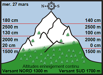
Image Off-Piste Snow Depths Haute Tarentaise, Savoie c/o Meteo France
A high-pressure weather system is now in place over the N French Alps, bringing dry sunny conditions until the end of March
The avalanche danger rating is down to 1 below 2500m and 2 in some places it is likely to remain that way until we see significant warming or new snow. There are a few slabs on high N and NW facing slopes above 2500m.
With this nice sunny weather ahead we’re hoping for lovely smooth ‘spring snow’ conditions to come into place very soon. They’re already appearing on sunnier slopes at low altitude, but we could do with some more intense heat in the day followed by good overnight refreezes for the lovely smooth conditions to become more widespread! Fingers crossed!
Smooth spring snow. H Schniewind photo from last April
What we mean by ‘spring snow’
We’re talking about the lovely smooth, soft snow that occurs in spring after a few melt-freeze cycles. Not the thick afternoon slush or rock hard morning snow that we also find in spring! Off-piste spring snow is one of the best things that the Northern French Alps has to offer. With lift access to all slope orientations: east, south, west and then north, you can find it and have fun with little effort.
Melt-freeze cycles
Following a few successive proper ‘melt-freeze’ cycles, or after a snowfall, the top snow layer begins to form a crust that gets deeper and stronger after each melt, allowing free water to drip down and re-freeze during the night. (A melt-freeze cycle is where the snow melts during the day and then freezes at night – that’s one melt-freeze cycle). Any given ‘melt-freeze’ layer becomes stronger with each cycle of melting and freezing, due to the deeper penetration of each melt during the day. This then adds more depth to the potential frozen layer at night.
If untouched, the top of this frozen layer is smooth and solid first thing in the morning. It softens as the day goes on as it melts in the warm sun and increased temperatures. The process starts on east facing slopes which receive the sun first. It moves onto the south, then the west facing ones, following the sun’s movement. (North facing slopes at 2500+ metres don’t normally get a melt freeze layer until late April, due to lack of sun).
Top tips for spring snow skiing
After a couple of good melt-freeze cycles have created a solid layer on a slope, the trick is to get on that slope when the snow surface is smooth and solid with only 2 or 3 cms of soft melted snow on top. These are generally slopes that have been in the direct sunlight only for an hour or so, e.g. an east facing slope at 9 or 10 am.
After a solid melt-freeze layer has formed and there’s been a good daytime melt, it needs to freeze well the next night in order for it to be right for the next day. The ideal is a cool clear night, with a minimum of –2° C (preferably lower) at 2000 m if you’re going to be skiing at this altitude and above. This will allow the melted parts of the layer to freeze solid again and pretty much guarantee that it will support your weight the next day.
So get on the east facing slopes, which get the sun first, as soon as the lifts open at 9 am. Then you move to south facing slopes, then west. Do this right and get some of the best skiing of the season.
You need to get off those slopes when the snow surface begins to get too soft and mushy or you’ll start breaking through. It’s important not to ski these slopes when they become soft and mushy because :
It’s dangerous for your knees.
The slope may become unstable due to all the melting. Then avalanches can be a problem on these sunny slopes.
You will leave nasty ruts in the snow which will ruin its quality for everyone who wants to ski it the next day.
Off-piste weather forecast for 21 to 29 March
Sunny day, softer in the afternoon. There is little or no morning greyness in the lowlands and valleys, but frost to the plain. Some fine clouds high at the end of the day.
Highest Temperatures (Slope South): , 9 ° C to 2000 m, 0 ° C to 3000 m.
NIGHT FROM THURSDAY 21 TO FRIDAY 22 More or less well starry. The fine, high clouds become more numerous at the beginning of the night, barely dense, then move away after midnight.
Lowest temperatures -6 ° C to 2000 m, -8 ° C to 3000 m.
For the day and the night:
At 3000 m, this locally moderate wind this morning, becomes strong in the morning, more moderate in the afternoon, then weak at night. Strong gusts (more than 60 km / h) from Foehn-Lombarde in the morning on the Italian borders, as well as downwind of the high ridges and passes of Beaufortain, Est Vanoise, Maurienne to Belledonnes, become less strong. afternoon and night.
FRIDAY 22 Another beautiful sunny day, warmer in the afternoon.
Night more or less well starry. Some passages of fine clouds very high, barely dense.
Isotherm 0 ° C rising everywhere around 2900-3000 m during the day, 2900-3100 m at night. Isotherm -10 ° C: 4500-4600 m. Wind at 2500 m: ENE at SE 10-30 km / h. Wind at 3700 m: East at ESE 20-40 km / h, then 20 km / h at the end of the night.
SATURDAY 23 Always good weather with a foehn wind weakening at 40/50 km / h and an isotherm 0 to 3000 meters.
SUNDAY TO THURSDAY The high pressure continues. The temperatures remain spring like reaching 9C at 2000m and OC at 3000m. The sun continues to shine.
Meteo France are on strike to protect the Bourg St Maurice weather and avalanche forecasting office.
Learn how to ski the lovely smooth spring snow correctly for maximum enjoyment by following our advice above.
Please note all snow reports are the opinions of local instructors and guides and are open to interpretation.
These snow reports are not the opinion of Tignes Spirit Rentals and we cannot be held responsible. Please check
with local Piste Hors / Ski Patrol before heading off-piste and always take up to date avalanche equipment and
know how to
use it!